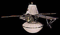
 Viking orbiter and lander together. |
 The Viking lander. |
Viking orbiter and lander together. |
The Viking lander. |
NASA's Viking Mission to Mars was composed of two spacecraft, Viking 1 and Viking 2, each consisting of an orbiter and a lander. The primary mission objectives were to obtain high resolution images of the Martian surface, characterize the structure and composition of the atmosphere and surface, and search for evidence of life. Viking 1 was launched on August 20, 1975 and arrived at Mars on June 19, 1976. The first month of orbit was devoted to imaging the surface to find appropriate landing sites for the Viking Landers. On July 20, 1976 the Viking 1 Lander separated from the Orbiter and touched down at Chryse Planitia. Viking 2 was launched September 9, 1975 and entered Mars orbit on August 7, 1976. The Viking 2 Lander touched down at Utopia Planitia on September 3, 1976. The Orbiters imaged the entire surface of Mars at a resolution of 150 to 300 meters, and selected areas at 8 meters. The lowest periapsis altitude for both Orbiters was 300 km. The Viking 2 Orbiter was powered down on July 25, 1978 after 706 orbits, and the Viking 1 Orbiter on August 17, 1980, after over 1400 orbits. The Viking Landers transmitted images of the surface, took surface samples and analyzed them for composition and signs of life, studied atmospheric composition and meteorology, and deployed seismometers. The Viking 2 Lander ended communications on April 11, 1980, and the Viking 1 Lander on November 13, 1982, after transmitting over 1400 images of the two sites.
The results from the Viking experiments give our most complete view of Mars to date. Volcanoes, lava plains, immense canyons, cratered areas, wind-formed features, and evidence of surface water are apparent in the Orbiter images. The planet appears to be divisible into two main regions, northern low plains and southern cratered highlands. Superimposed on these regions are the Tharsis and Elysium bulges, which are high-standing volcanic areas, and Valles Marineris, a system of giant canyons near the equator. The surface material at both landing sites can best be characterized as iron-rich clay. Measured temperatures at the landing sites ranged from 150 to 250 K, with a variation over a given day of 35 to 50 K. Seasonal dust storms, pressure changes, and transport of atmospheric gases between the polar caps were observed. The biology experiment produced no evidence of life at either landing site.
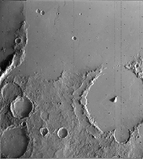 Lava flow and craters at Pickering Crater. The lava flow is from Arsia Mons, about 1500 km away. This Viking 1 obiter image is about 180 km wide. |
 Viking 1 orbiter image of the Dromore Crater in Chryse Planitia. The crater is 15 km in diameter. Notice the flow from the left (west) which breaks around the crater. |
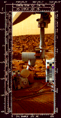
 Volcanic rocks and the view of Utopia Planitia from Viking 2 landing site. |
 Patches of ground frost at Viking 2 lander site. The frost is a few hundreths of a mm thick. It is probably a mixture of water and carbon dioxide. |

Goto Section 4 - Space Based Exploration 1990 to Present.
Goto Section 4 - Space Based Exploration, the 1990's (2003 version).