I am an engineering geologist interested in research about soil and rock mechanics, slope stability, and erosion. My current study can be divided into three broad categories (i) Slope Stability Hazard and Risk evaluation using field and geospatial models, (ii) Soil Erosion, Weather Pattern, Metal Transport, and (iii) Wetlands Soil and Restoration Efforts.
RECENT FUNDED RESEARCH
(2020-2024)
-
Nandi, A. (Principal), Joyner, T. A. (Co-Principal), Ernenwein, E. G. (Co-Principal), Kane, W. (Supporting), Forsthoff, B. (Supporting), "Landslide and Debris Flow Monitoring for Improved Highway Safety and cost savings ," Sponsored by TDOT, State (August 2022 - January 2024).
Recent improved tools and methods for geotechnical asset management (GAM) indicate a need for updated slope hazard management practices along highways. Statewide slope asset inventories can benefit from mobile GIS tools and standardized workflows based on the 2019 federal Unstable Slope Management Program (USMP). In this project, current best practices were reviewed for hazard and risk assessment protocols, mobile GIS inventory tools, and slope monitoring with unmanned aerial systems (UAS). The findings were applied in developing a comprehensive approach to statewide soil slope management for use by Tennessee Department of Transportation (TDOT). The study objectives were to (i) adopt a soil slope rating system modified for Tennessee roadways based on the federal USMP, (ii) create and test a digital mobile USMP survey form with Survey123, and (iii) perform one-year UAS monitoring and limit equilibrium analysis for selected hazardous slopes. The resulting Tennessee USMP scheme calculates hazard and risk ratings for soil slopes assets according to 55 user input criteria. The Survey123 USMP form was coded to automatically generate scores and create GIS records in an Esri cloud database appended with site data, photos, field notes, and hazard and risk ratings. A field trial of the system generated twenty-two slope ratings with USMP scores ranging from 369 (Fair) to 1104 (Poor). Six high-risk sites were selected for UAS monitoring with data collection flights performed in leaf-off conditions in 2023 and 2024. These produced a one-year time series of digital elevation models (DEMs), orthoimages, and raster derivatives, which were compared to existing 2016 LiDAR to identify slope movements and map emergent landslide features. Elevation profiles were extracted from DEMs to produce cross-sections for limit equilibrium modeling of predicted slope failures. This project presents a feasible and effective multi-step approach for improving slope assessment, inventory, monitoring, and GIS data management for soil slope assets along Tennessee highways.
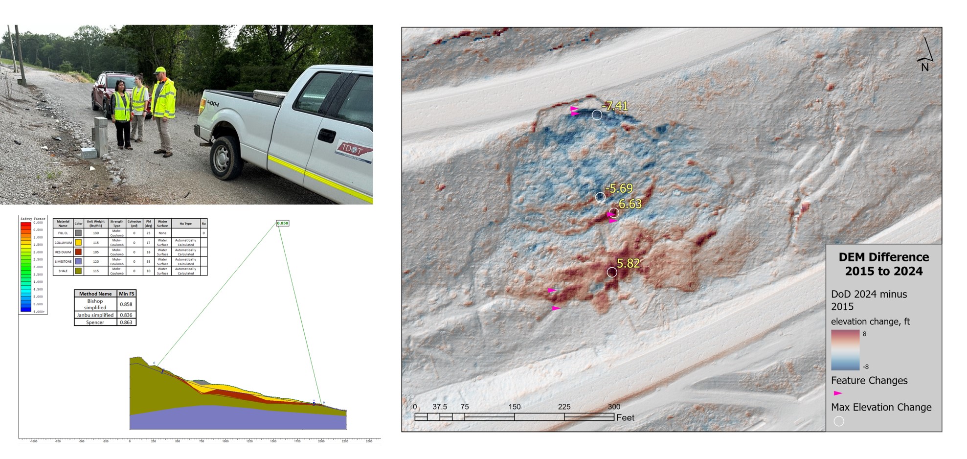
Landslide Site Investigation (Field, Remote, Stability Analysis, Figures by Robert McSweeney).
----------------------------------------------------------------------------------------------------------------------------------------------------
-
Ernenwein, E. (Principal), Nandi, A. (Co-Principal), Luffman, I. (Co-Principal), Joyner, T. A. (Co-Principal), “ Impact of Hurricane Helene on Marginalized Mountain Communities of East Tennessee” , Sponsored by National Center for Airborne Laser Mapping (NCALM) NOW (2024)
Hurricane Helene left a significant mark in the Southern Appalachians, including East Tennessee (ETN). On September 27th, the Watauga/Doe, Nolichucky, Upper French Broad, and Pigeon rivers all entered Major Flood stage or set record stream heights, and rainfall totals exceeded the predicted 18 inches in many areas. The water level in Watauga Lake (ETN) exceeded the previous record by 3 feet, and the Nolichucky River gage at Embreeville, TN (03465500) was on track to record a Major flood stage but was swept away several hours before peak water levels were reported along that river (Tennessee September Climate Summary, pp 15-23, bit.ly/sept24_tn). Post-disaster aerial imaging (bit.ly/tnresponse) shows a dramatic reshaping of hillslopes, valley floors, floodplains, and river channels. We summarize the event with maps, videos, UAV imagery here: bit.ly/tnhelene24.
This project acquired LiDAR and Aerial Imageries from Doe River watershed, a mostly forested region extending from the NC border down to the City of Elizabethton in the Valley and Ridge physiographic province. It encompasses a wide range of elevations, ecosystems, geologic formations, and river morphologies. Population centers include Hampton (population 2,030), and Roan Mountain (population 984), where homes were swept away and a high school irreparably damaged. Hydrographs show that stream stage peaked at 10.78 ft, just 0.14 inches below the Doe River at Elizabethton record set in 1998 (NWS 1998, tinyurl.com/muae2taw). Capturing post-disaster LiDAR here will allow us to approach our research questions and assist local government and organizations with post-disaster recovery in a highly vulnerable and neglected region.
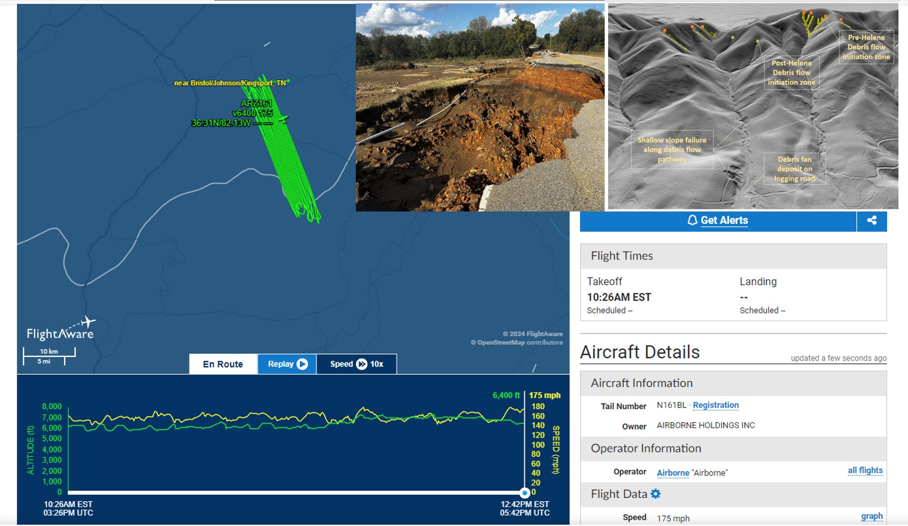
LiDAR Data Aquisition for Doe River Area, TN.
-------------------------------------------------------------------------------------------------------------------------------------------------
- Nandi, A. (Principal) Unstable slope assessment and landslide monitoring in urban communities (ongoing 2017-2024).
Urban areas in eastern Tennessee has begun expanding, open and flat areas have become rarer.
This leaves home and property planners to look to other undeveloped areas, notably the topographically elevated ridges around the north and southwestern regions of the county.
Development on steep slopes has resulted in landslides. The most common types of slope failures are rotational slides, with land surface rupture following a curved path, and translational slides, which move along a planer surface. These slides often convert to small debris flow due to the significant amount of rainwater along the soil colluvium.
Story Map: https://arcg.is/1zT9HS
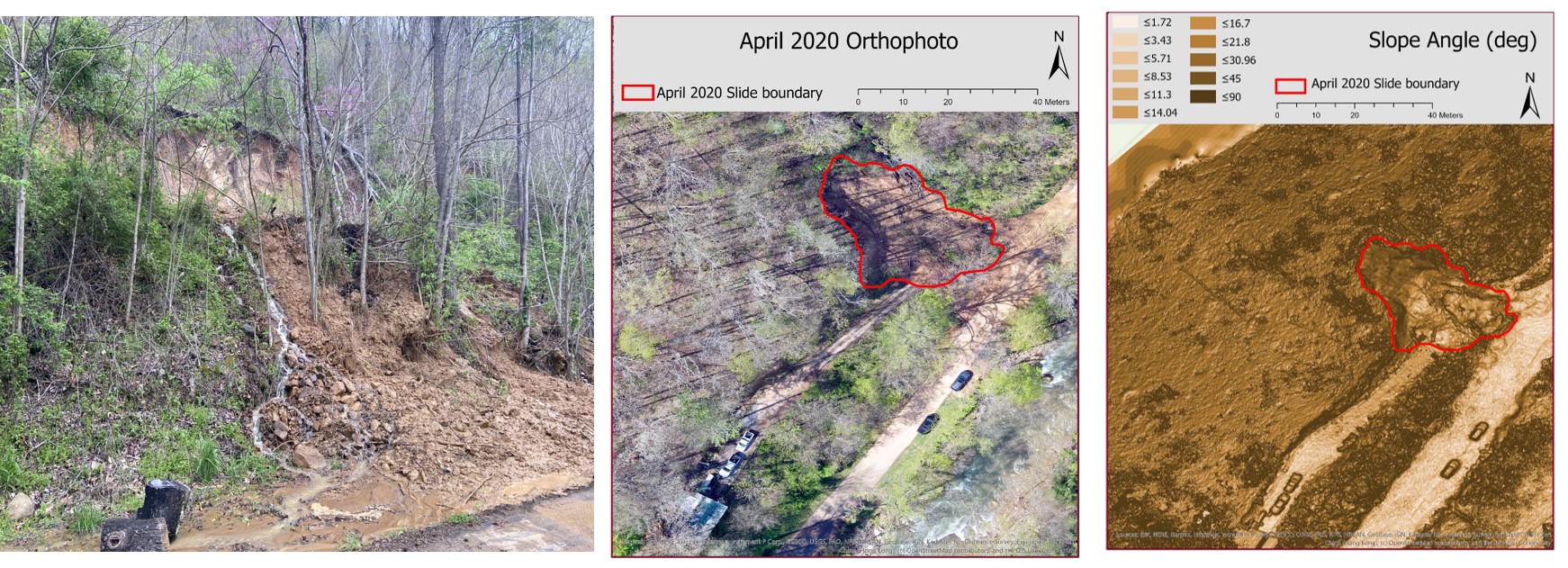
Urban Landslides in Tennessee
------------------------------------------------------------------------------------------------------------------------------------------------
-
Nandi, A. (Project Personnel) Landslide susceptibility and risk assessment for the island of Dominica, (2023 - 2024), part of the Connecting Communities for Climate and Disaster Risk Preparedness Initiative Sponsored by CCC-DRIP.
The Eastern Caribbean island of Dominica is vulnerable to hydrometeorological and Geological hazards such as landslides, floods, hurricanes, tropical storms, and volcanism. Floods and landslides from high-intensity rainfall from tropical storms and hurricanes account for the majority of the natural hazards. In recent years, the island was severely impacted by Hurricane Maria in 2017 and TS Erika in 2015, which led to massive landslides along major roadways as well as riverine and coastal flooding. An assessment of the landslides and flooding in Dominica was carried out in February 2023 as a part of the International Development Research Centre (IDRC) of the Government of Canada's funded project "Connecting Communities for Climate and Disaster Risk Preparedness (CCP-DRiP): A Research Development Based Approach in Dominica."
The survey was conducted from the island's West to the East coast along main roadways and coastal areas. It was seen that along the Grand Bay Main Road from West to east, several slides were activated or reactivated during Maria in 2017. The Bellevue_Chopin community was impacted, and some housing was relocated. A new landslide opened in November 2022. The community of Pichelin was heavily impacted by both landslides and floods at locations. Landslides destroyed a church, health center, school, and village houses. This area was known to be impacted by both Hurricanes Erica (2015) and Maria (2017). Other areas that were significantly affected by landslides were the Dubic and Bagatelle, which damaged houses and roads. Community of Good Hope, San_Sauveur, and Petite Soufriere were severely impacted by large-scale landslides during the 2022 tropical storm, killing people and destroying roads, crops, and cattle. Flooding was also seen to affect houses and infrastructures in low-lying communities along the entire west coast of the island. A preliminary landslide and flood hazard assessment using GIS-based methodology showed that the major controls were lithology, proximity to streams, presence of fractures/faults, and heavy rainfall.
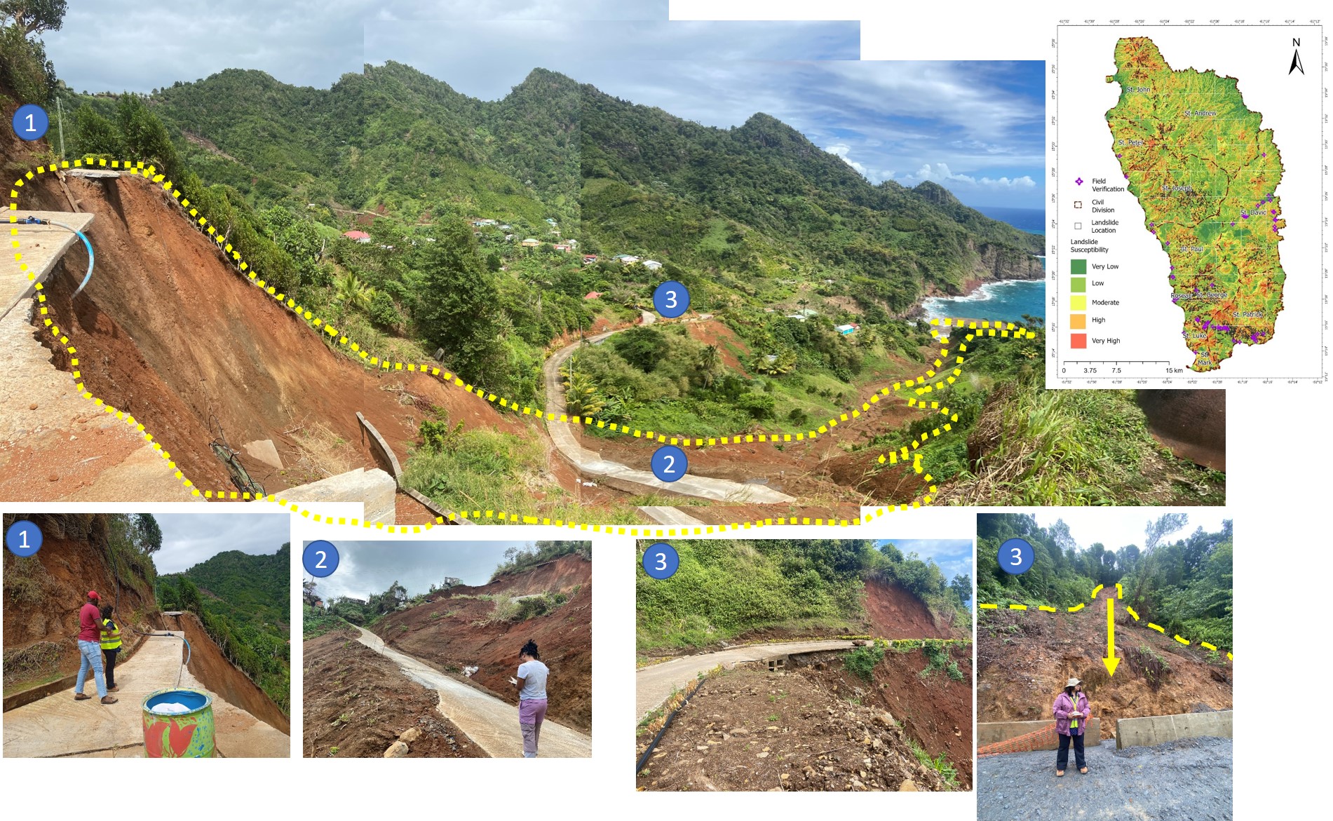
Some Landslide Complex in Dominica
--------------------------------------------------------------------------------------------------------------------------------------------------
-
Nandi, A., (Principal) Analysis of High Priority Unstable Rock Slopes in Great Smoky Mountains National Park, Tennessee, and North Carolina . Sponsored by the National Park Service (NPS). CESU (Cooperative Ecosystem Studies Unit) Grant. (2020-2022).
An important first step of geotechnical asset management in Great Smoky Mountains National Park (GRSM) is the creation of an unstable slope inventory along major transportation corridors. Slope stability problems are frequent in GRSM, often initiated in highly weathered, fractured metasedimentary rocks. In this study, an unstable slope inventory was created using the Unstable Slope Management Program for Federal Land Management Agencies protocols. Hazards and risks were evaluated for 285 unstable slopes along 243.67 km of roadway. Kernel Density Estimation was used to identify unstable slope hotspots and establish fourteen sites for site-specific investigations to evaluate potential impacts of discrete unstable slopes along major roadways. Two-dimensional probabilistic rockfall simulations and Acid Base Accounting tests were used to predict rockfall pathways and evaluate the acid-producing potential of rocks. Simulations indicate that rock material would likely enter the roadway at all fourteen sites. Acid Base Accounting test results indicate that influence of Acid Rock Drainage on rockfall outcomes are generally confined to slaty rocks of the Anakeesta Fm. and graphitic schist of the Wehutty Fm. The research illustrates an approach for prioritizing areas for site-specific investigations towards the goal of improving safety in GRSM, such as, developing mitigation strategies for rockfall by widening ditches, installing barriers, and encapsulating acidic rockfall material.
Story Map: https://arcg.is/10Sunr
Publication :
O’Shea T.*, Farmer, S.*, Nandi, A., Bilderback, E., Luffman, I., and Joyner, A., “Inventory of Unstable Slopes to Prioritize Rockfall Modeling and Acid-Base-Accounting in Great Smoky Mountains National Park,” Environmental & Engineering Geoscience, Vol. XXIX, No. 2, May 2023, pp. 73–91.https://pubs.geoscienceworld.org/aeg/eeg/article/29/2/73/621468/Using-an-Inventory-of-Unstable-Slopes-to
Das, R.*, Nandi, A., Luffman, I. et al. Assessment of discontinuity-controlled rock slope instability for debris slide initiation: a GIS-based kinematical analysis in the Great Smoky Mountains National Park, TN, USA. Environ Earth Sci 83, 284 (2024). https://link.springer.com/article/10.1007/s12665-024-11578-2
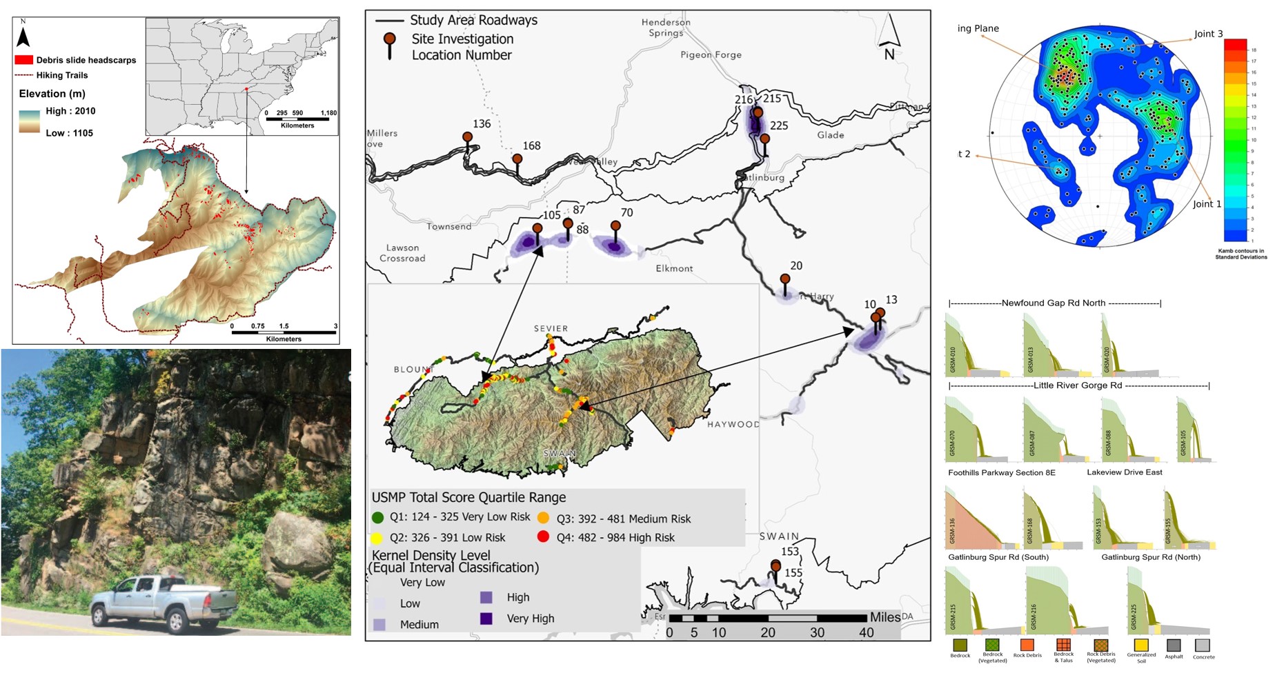
Rockfalls in Great Smoky Mts National Park (Figures Thomas O'Shea and Raja Das).
---------------------------------------------------------------------------------------------------------------------------------------------------
- Joyner, T. A. (Principal), Tollefson, W. C. (Co-Principal), Luffman, I. E. (Co-Principal), Ernenwein, E. G. (Co-Principal), Nandi, A. (Co-Principal), Quinn, M. A. (Co-Principal), "Developing climate risk assessments for the Tennessee Hazard Mitigation Plan update (2023) ," Sponsored by FEMA, Federal, (December 2022 – December 2023).
---------------------------------------------------------------------------------------------------------------------------------------------
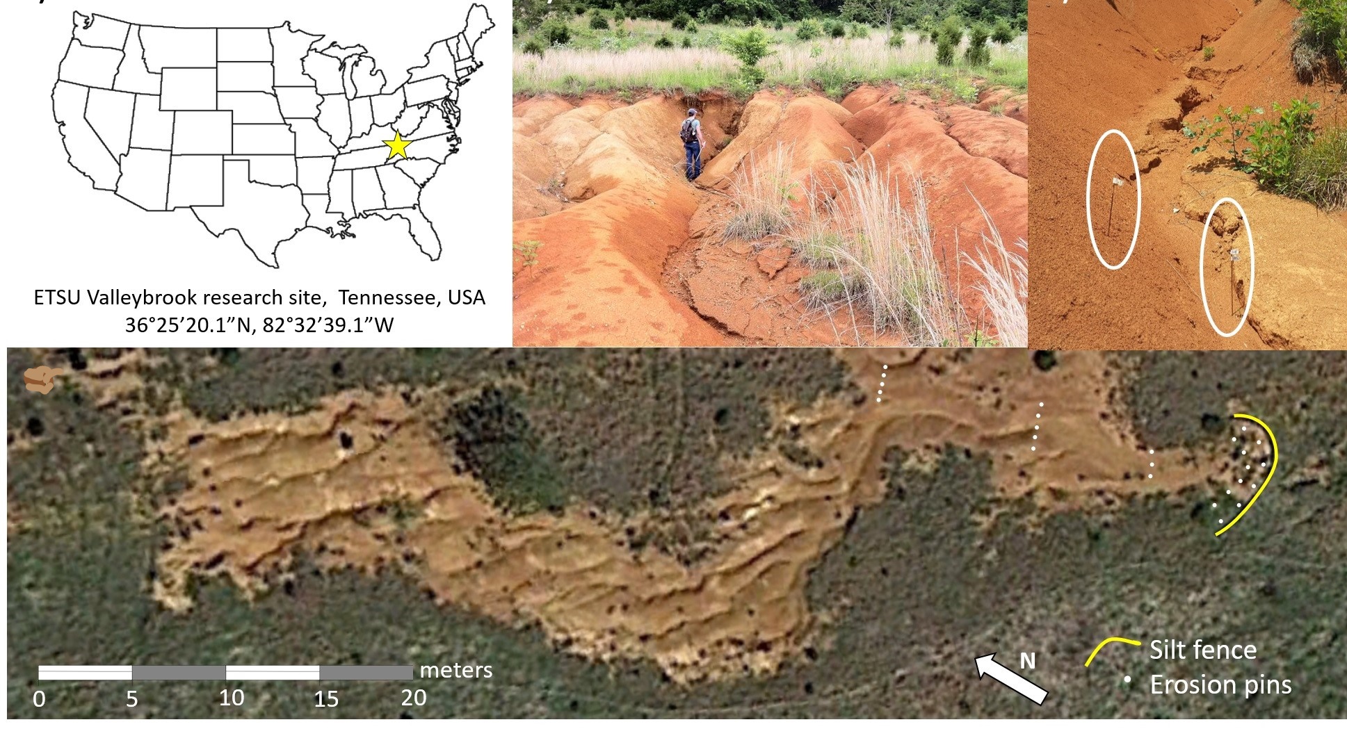
- Luffman, I. (PI) and Nandi, A. (Co-PI) “ Seasonal precipitation variability and gully erosion in Southeastern USA .” This project is funded by ETSU internal grants.
Soil erosion is a serious land degradation problem in Appalachian hillslopes, and is often associated with improper land management practices. Erosion in these soils commonly takes the form of gully erosion in fine grained silty and clayey soils. Through series of collaborative studies our research team investigates the gully erosion morphology, soil characteristics and effect of weather pattern on gully erosion on a Appalachian hillslopes.
|
| Gully Erosion in site at the Soil and Water outdoor lab at ETSU (image by Ingrid Luffman) |
-----------------------------------------------------------------------------------------------------------------------------------
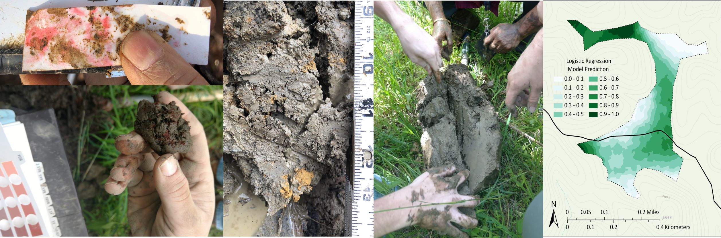
- A. Nandi., (Principal) Delineation of Wetland Boundary based on soil properties, Cutshaw, Davils Kitchen Bog of the Cherokee National Forest . Sponsored by National Forest Service (2019-2020).
Wetlands are defined as areas that are saturated frequently enough to support vegetation adapted for life in saturated soil conditions. Wetlands generally include swamps, marshes, bogs, fens, and similar saturated environments. Wetlands in the Cherokee National Forest has been impacted by a number of factors. Its history has been riddled with common flood occurrences, excess sedimentation from an eroding dirt road in the middle of the bog with a sloped elevation, land misuse from off road vehicles, and hunting stands built in the bog. Due to these factors, the wetland is in need of restoration. Before restoration can occur, a baseline soil analysis of hydric soil condition is necessary.
|
| Sample pictures from Wetland Soil Study, Cherokee National Forest |
------------------------------------------------------------------------------------------------------------------------------------------------
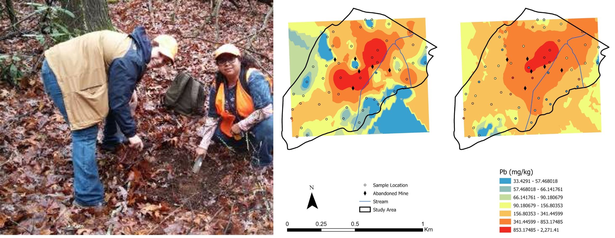
- Luffman, I. (PI) and Nandi, A. (Co-PI) “ Heavy metal contamination in soil, Bumpass Cove, TN .” This project is funded by ETSU internal grants.
Mining, manufacturing, and fertilizers, pesticides etc. can result in heavy metal contamination in soil and groundwater. Heavy metals also occur naturally in bedrock and leach out to groundwater under specific geochemical conditions. The spatial distribution of heavy metals in soil and groundwater is important in assessing soil quality and locating source of the contaminants. Student researchers use combination of field, laboratory work, and geostatistical analysis using GIS to study heavy metal contaminations.
Heavy metal contamination in soil and groundwater
|
| Mine soil study (Figures Melissa Magno) |